Leave a Reply
Want to join the discussion?Feel free to contribute!
Route Name: Lithophonic
Application Status: Approved
Application Cycle: current
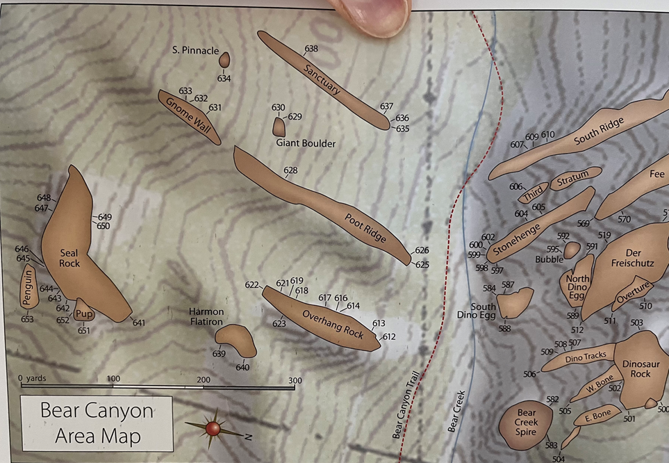
Rock Formation: Stonehenge
Number of lead bolts to be placed: 13
Number of anchor bolts to be placed: 2
Route Difficulty:5.13-
Route Diagrams:
Proposed Route:
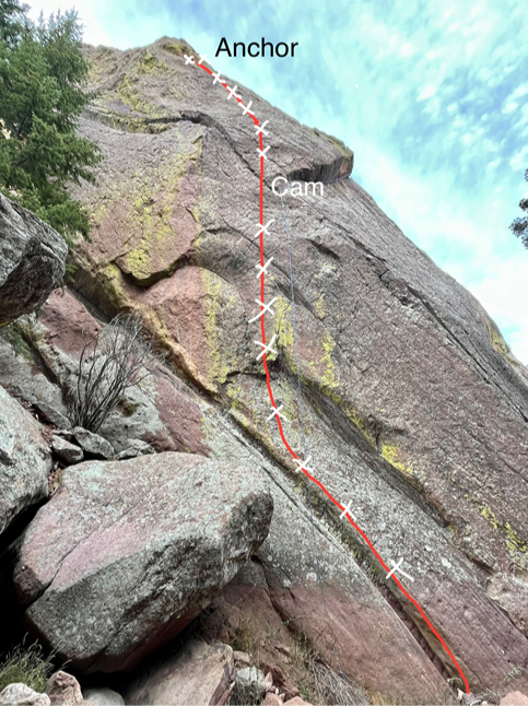
Start from the creek bed on the left side of the south face. Climb up and left through a left leaning runnel/dike feature past 3 bolts, then climb straight up past 5 more bolts through the crux. A bolt 5, the angle eases off through easier terrain. Place a hand sized cam in a diagonal crack feature, then follow 5 more bolts through moderate terrain, trending left at the top toward the anchor. *During high water when the creek is running, you can start the route by approaching from the left hill side and stepping off a boulder and climbing out right to reach bolt 4. *Between bolts 5 and 6, the route crosses directly over the existing route “Old Man of Hoy”, which traverses diagonally across the wall from right to left. A #1 or #2 Camalot placement can be used for protection through this area. None of the proposed new bolt placements will interfere or be able to be reached from the existing trad route. The crux of the route is located between bolts 4 through 8. The angle then eases off a bit, and the climbing becomes more moderate. Enjoyable 5.10/5.11 climbing on good edges and crimps lead up and slightly left to the proposed anchor location. The total length of the route is approximately 95 feet from the base of the route.
Name Meaning:
“Lithophonic” refers to rocks that produce sound when struck, often used to make a musical instrument called a lithophone.
Existing Route Information
There are currently ten existing routes on Stonehenge. From left to right: Exploratory Surgery 5.6X Trad Mountaineer’s Route 5.4 Trad Measure for Measure 5.10b R Trad Thought Control 5.10a R Sport Old Man of Hoy 5.10c R Sport Stonehenge Project, Abandoned, single ring bolt Auspice 5.11d R Sport Stonehenge Mix Route 5.12b Mixed The Sculpture 5.11c TR The Fiend 5.13c Mixed “Lithophonic” will be located approximately 20 feet right of “Auspice”, and 20 feet left of “Old Man of Hoy” Due to the nature of the crag, a photograph and topo of all existing routes is not available.Existing Route Diagrams
A description of the approach (include approximate distance from the designated trail system, existing “social” or undesignated trails leading to the climb and condition of the trail, and state whether there is a durable surface, such as rock.
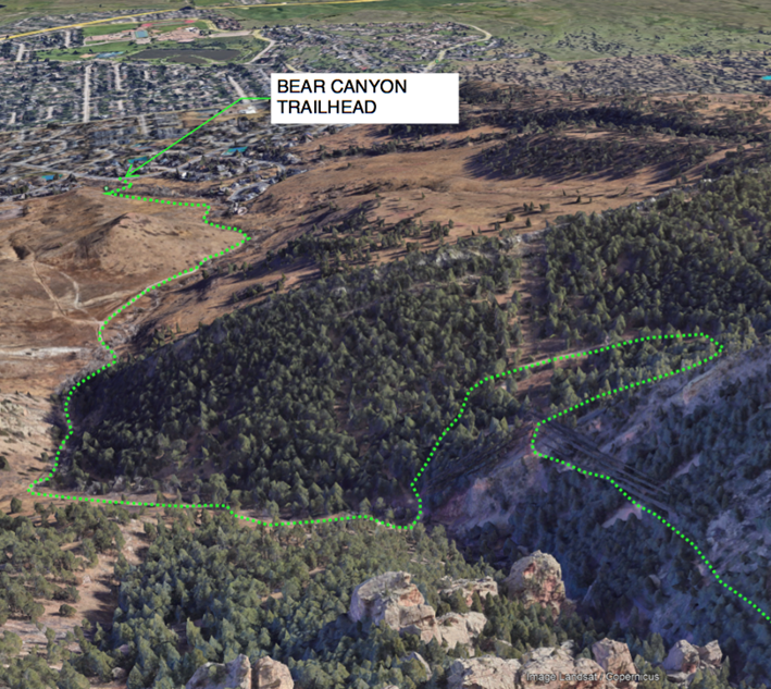
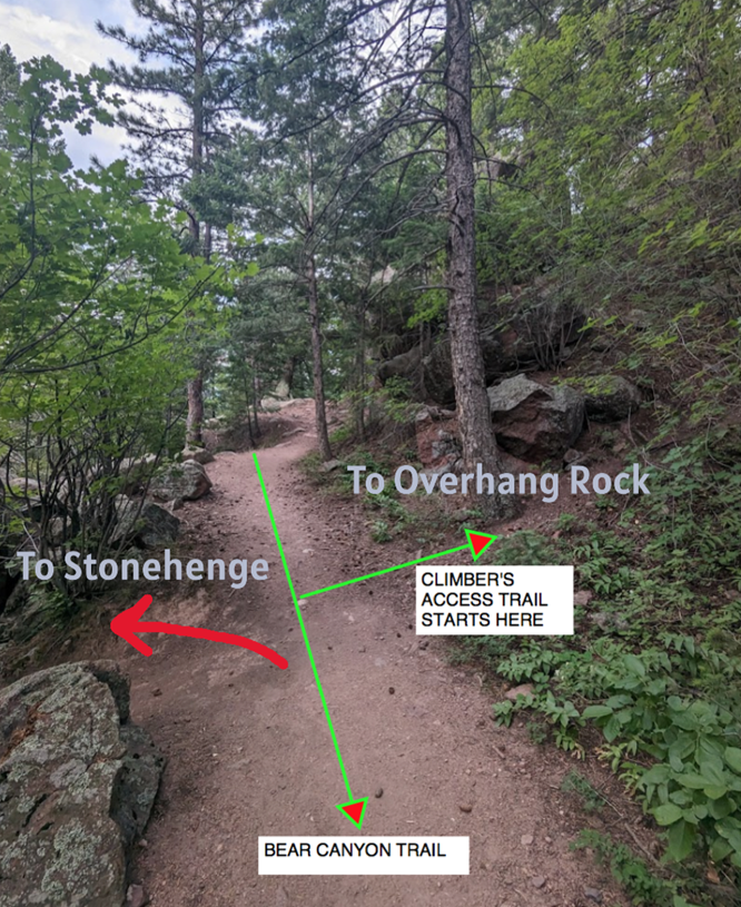
The approach to Stonehenge is well established. Hike up the Bear Canyon Trail for about 35-45 minutes to just past the cutoff trail the heads south east toward Overhang Rock. Continue downhill to the north on a short climber’s trail toward the creek bed once you are in line with the route “Thought Control”, which can be easily seen across the creek from the trail. Cross the creek bed to arrive at the wall. In Spring and Summer when the creek is flowing, you can hike a bit further up the Bear Canyon Trail until just before a smaller creek crosses the trail. From here, take a slab descent downhill towards the main larger creek. Cross the creek at some boulders and go slightly uphill to reach the base of the formation close to the route “The Fiend”. From the base of the wall walk downhill to the edge of the creek on its north side.
If different from the approach, a description of the descent, (include approximate distance from the designated trail system, existing “social” or undesignated trails, a description of the trail condition and whether there is a durable surface, such as rock. Include photographs of the descent.):
Rappel or lower off the route back to the base and reverse the approach for the descent.
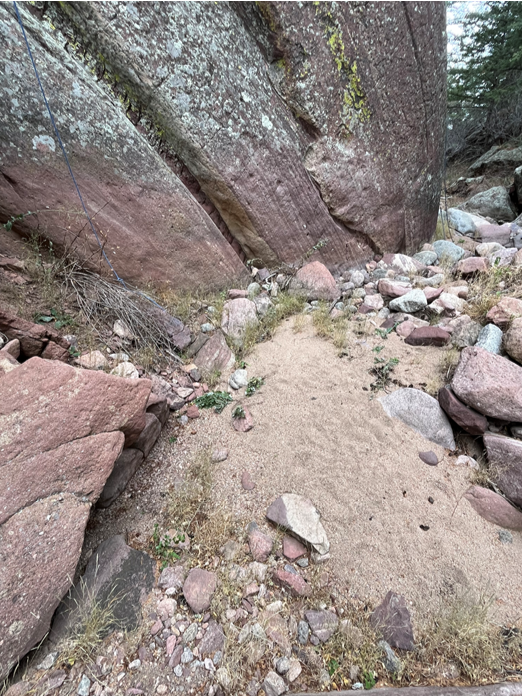
A description of the area at the base of the climb (include existing levels of soil compaction, existence of a durable surface such as rock, and existing soil erosion. Include photographs of the area at the base of the climb.):
The base of the climb consists of durable ground on the flat sandy creek bed, or from the top of a large flat boulder up and left where the technical climbing starts.
Has all reconnaissance work that can be reasonably done, short of placing any hardware, been done?
Base Area Photos
Has the route been top roped? Is there loose rock? Is it extremely overhanging?
The route has been successfully top roped, and all the moves have been freed at a proposed grade of around 12+/13-. The rock quality is excellent from start to finish, with no loose rock. No cleaning is required. The route is vertical for the first half, then the angle gradually decreases on the second half.
Any additional notes:
This route will be an excellent addition to the Bear Canyon area. It consists of excellent, clean rock throughout the entire length, and will require no cleaning.

Looks good! Yes from me.
Looks great! I vote yes.
Beautiful line, I’m all for it!