Route Name: Sixth Extinction
Application Status:
Application Cycle: 2026
Rock Formation: Dinosaur Rock
Number of lead bolts to be placed: 6
Number of anchor bolts to be placed: 4
Route Difficulty:
Route Diagrams:
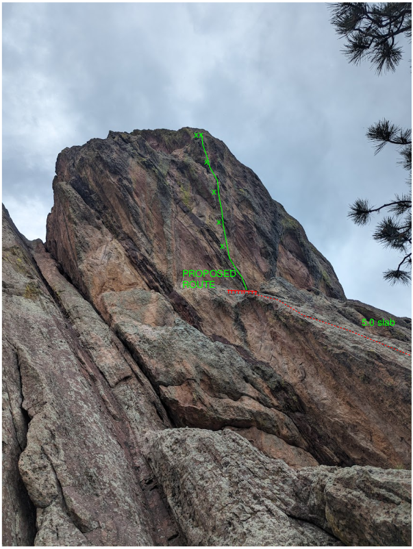

Proposed Route:
The proposed route ascends the south face of Dinosaur Rock, starting about 50 ft right of Pink Man’s Burden. Climbers scramble up a 5.0 slab to a small ledge to start the route. Clip the first two bolts from the ledge, and pull on to the boulder problem crux. About 40 ft of hard climbing through overhanging pinches and big moves leads to a 2-bolt anchor.
Name Meaning:
The Sixth Extinction, refers to the Holocene Extinction event, the 6 th of the great extinction events in Earth’s history.
Existing Route Information
There are only 2 routes on the south face of Dinosaur rock. Pink Man’s Burden - 5.11d, 2-pitch bolted route South Ramps – 5.4 trad The proposed route starts about 50 ft right of Pink Man’s Burden, and about 100 ft left of south ramps.Existing Route Diagrams


A description of the approach (include approximate distance from the designated trail system, existing “social” or undesignated trails leading to the climb and condition of the trail, and state whether there is a durable surface, such as rock.
Approach from NCAR. Follow the Mallory Cave trail until it reaches Dinosaur Rock. Then branch left (south) on a well established climber’s trail to the south side of Dino Rock. Reach the base of the route by ascending about 50 ft of 5.0 slab.

If different from the approach, a description of the descent, (include approximate distance from the designated trail system, existing “social” or undesignated trails, a description of the trail condition and whether there is a durable surface, such as rock. Include photographs of the descent.):
Climbers descend by lowering off the route with a 40 m rope
A description of the area at the base of the climb (include existing levels of soil compaction, existence of a durable surface such as rock, and existing soil erosion. Include photographs of the area at the base of the climb.):
The base of the climb is solid rock (rock ledge)
Has all reconnaissance work that can be reasonably done, short of placing any hardware, been done?
Base Area Photos

Has the route been top roped? Is there loose rock? Is it extremely overhanging?
Yes – some sections of the route have been top roped, but due to it being extremely overhanging, the entire route has not been freed. There is minimal loose rock
Any additional notes:
Not provided
News and Events
 OSMP/FCC Trail Day at The Slab: Trip ReportJuly 27, 2026 - 2:59 pm
 FCC/OSMP Trail Volunteer Day at the Slab July 25July 7, 2026 - 10:59 am
 2025 Flagstaff Trash Bash – September 4July 30, 2025 - 5:31 pm
 Trail Volunteer Day – Hillbilly Crag, October 26, 2024September 29, 2024 - 4:00 pm
 Golden Eagle Closures – New PeriodNovember 27, 2022 - 12:54 pm
- Trail Volunteer Day – First Flatiron, September 24August 24, 2022 - 10:54 am

Looks like a great route. Tyrannosaurus Yes from me.
Looks cool, I vote yes