Route Name: Morning Sunlight
Application Status: Approved
Application Cycle: 2025
Rock Formation: Mickey Mouse
Number of lead bolts to be placed: 18
Number of anchor bolts to be placed: 6
Route Difficulty:5.12-
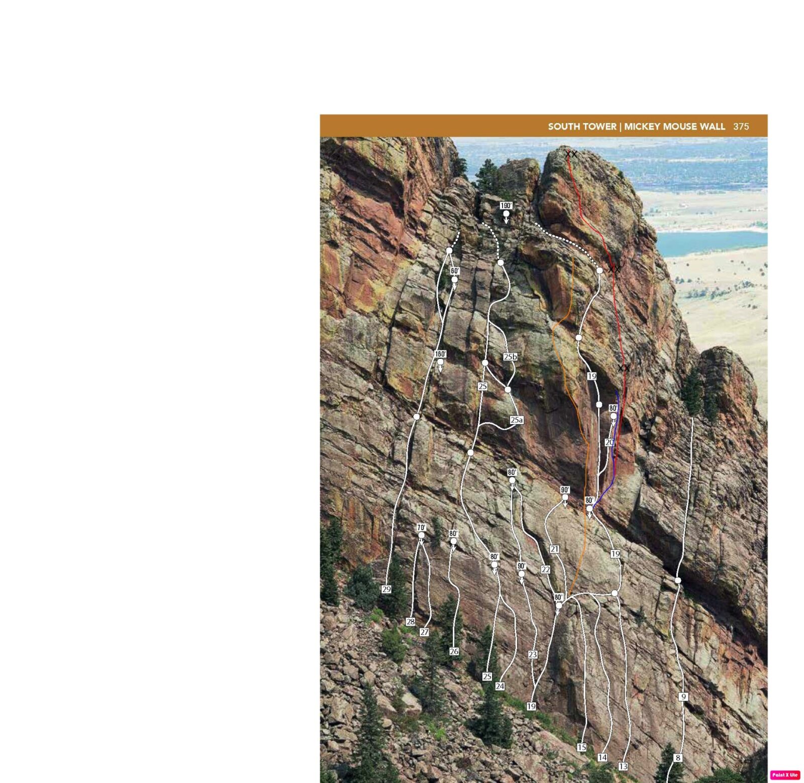
Route Diagrams:

Proposed Route:
This route consists of three new pitches. The first pitch starts on Blush, but rather than tackling the steep face, it climbs the corner system just to the right and will be mixed gear and bolts. The second and third pitches climb the face above to the top of the South Tower. The rough estimate of grades is P1: 5.11+/512-, P2: 5.7, P1:5.10. The route can be accessed a few different ways. One option is to start on Asahi (5.10c) and then climb the second pitch of Red Dihedral (10a). This approach leads directly to the start of the climb and will create a sustained five-pitch route of consistent style (mixed bolts and gear) and a relatively consistent grade. The route can also be approached from the left by climbing the first pitch of Red Dihedral and the first pitch of Red Arete, or from the right by scrambling up and left across a ramp that leads to a tree (5.0?). From the tree, climb the second pitch of Luna Line (5.8) or scramble up the face just to the left (5.5?).
Name Meaning:
Not provided
Existing Route Information
There are numerous routes on Mickey Mouse Wall that are well documented in Steve Lavin’s “Eldorado Canyon, A Climber’s Guide”. The established routes include a mix of trad and sport. Routes in the immediate vicinity include: 13: Asahi (5.10c, trad/bolted) 14: Perilous Journey (5.11c, trad) 15: Krystal Klyr (5.11a, trad) 19: Red Dihedral (5.12d trad) 20: Stigmata (5.13b, trad/bolted) 21: Boxcar Willie (5.11a sport) 22: The Green Dihedral (5.7+, trad) 23: Plane Geometry (5.12b, mostly bolted) 24: Leap of Faith (5.12a, trad) 25: Simian’s Way (5.10 trad) 26: Mighty Mouse (5.12a bolted) 64: Three Mouseketeers (5.11c bolted) Orange Line: Red Arete Blue Line: Blush (approved route that has not been equipped but not completed) Red Line: Proposed Route The attached photo gives an indication of the distance of these climbs from the proposed route. Thanks to Steve Lavin for use of this photo.Existing Route Diagrams
A description of the approach (include approximate distance from the designated trail system, existing “social” or undesignated trails leading to the climb and condition of the trail, and state whether there is a durable surface, such as rock.
The approach to Mickey Mouse Wall is well documented on Mountain Project. Here is an excerpt: To reach Mickey Mouse Wall, take the road to Eldo and turn left on County Road 67 (paved) right before the town. Go about 300 yards to a locked gate. Park here. Hike up the maintained gravel road, avoiding a left after about 0.5 mile, and continue through a rock cut. Continue hiking up the road aka "Fowler Trail" avoiding a few single track trails heading off to the right. Continue hiking up the road avoiding roads that go off to the right up to the Conda Quarry. At an intersection with a road and a gate on the right continue straight onto a double track for about 100 feet and then take a right onto a single track. Continue on the single track avoiding a left single track aka "Goshawk Ridge Trail" all the way to the train tracks. When you arrive at the tracks, turn left and walk along the east side of the tracks towards the tunnel (tunnel 6). About 20 feet before the tunnel, take a faint trail up the dirt berm on the left. The wall is immediately on the other side of the tunnel. Please DO NOT go through the tunnel. You will climb approximately 200 feet contouring uphill to skirt around the east side of the tunnel, generally paralleling the direction of the tracks. Eventually you will crest the ridge and start descending, continuing to contour around the ridge until you arrive back at the tracks. Promptly cross the tracks and continue towards the wall on the southwest side of the tracks. There is a very poor trail right under the wall, and big talus (preferable) a little to the left. Hike up to your route.

If different from the approach, a description of the descent, (include approximate distance from the designated trail system, existing “social” or undesignated trails, a description of the trail condition and whether there is a durable surface, such as rock. Include photographs of the descent.):
The descent will be via lowering off the route.
A description of the area at the base of the climb (include existing levels of soil compaction, existence of a durable surface such as rock, and existing soil erosion. Include photographs of the area at the base of the climb.):
The staging area depends on the first approach used to get to the route. In all cases, the new route is approached from existing routes.
Has all reconnaissance work that can be reasonably done, short of placing any hardware, been done?
Base Area Photos

Has the route been top roped? Is there loose rock? Is it extremely overhanging?
Yes, all three pitches have been top-roped and inspected for loose rock.
Any additional notes:
Will make a great five-pitch adventure route with a reasonable grade that should make it accessible to many climbers.
News and Events
 OSMP/FCC Trail Day at The Slab: Trip ReportJuly 27, 2026 - 2:59 pm
 FCC/OSMP Trail Volunteer Day at the Slab July 25July 7, 2026 - 10:59 am
 2025 Flagstaff Trash Bash – September 4July 30, 2025 - 5:31 pm
 Trail Volunteer Day – Hillbilly Crag, October 26, 2024September 29, 2024 - 4:00 pm
 Golden Eagle Closures – New PeriodNovember 27, 2022 - 12:54 pm
- Trail Volunteer Day – First Flatiron, September 24August 24, 2022 - 10:54 am


Looks like a great addition to that wall, I’m in favor of getting this rig approved.
Looks fun, I say yes!
Looks great. Approve it.
Big Yes
Looks AWESOME!!!! Yes!
Heck yeah!