
Route Name: Pile in the Sky
Application Status: Approved
Application Cycle: 2018
Rock Formation: Third Flatiron
Number of lead bolts to be placed: 13
Number of anchor bolts to be placed: 2
Route Difficulty:5.12a
Route Diagrams:

Proposed Route:
Proposed route, Pile in the Sky (5.12a, 33 meters), is an entirely independent line on the south face of the Outter Wedge of the Third Flatiron. The first 20 meters of the route is mid 5.10 climbing on big holds with numerous good rests. The last 13 meters is sustained 5.11 (vertical to slightly overhanging), with a brief 5.12a crux 5 meters below the anchor. The rock quality is good. A 70 meter rope will be mandatory for this route.
Name Meaning:
Not provided
Existing Route Information
There are no reported routes on this face. The nearest route is Inner Sanctum 5.9, on the west face of the Outter Wedge. Inner Sanctum and Pile in the Sky share no common ground.Existing Route Diagrams
A description of the approach (include approximate distance from the designated trail system, existing “social” or undesignated trails leading to the climb and condition of the trail, and state whether there is a durable surface, such as rock.
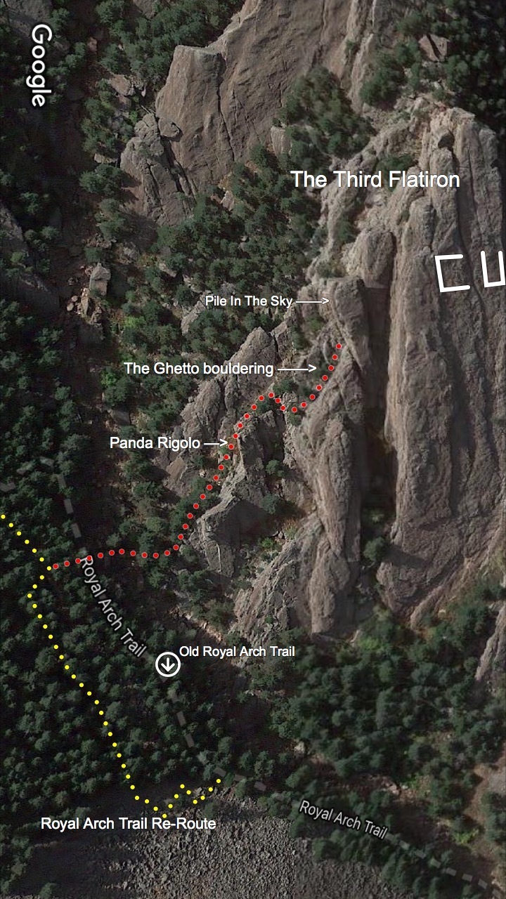
The approach is as for The Ghetto bouldering area. From the Royal Arch Trail make a short descent on a social trail (the southern Third Flatiron descent trail) to a creek bed, then ascend the gully on the west side of W.C. Fields Pinnacle for 200m. At a notch, on the north side of an unnamed formation just north of W.C. Fields Pinnacle, scramble up right/east (5.2) into the Ghetto (see Ghetto approach photo). Once in the Ghetto (The Ghetto is a small gully/ramp with bouldering on its east side) walk/scramble north to the base of the Outer Wedge.


If different from the approach, a description of the descent, (include approximate distance from the designated trail system, existing “social” or undesignated trails, a description of the trail condition and whether there is a durable surface, such as rock. Include photographs of the descent.):
Descend the approach through The Ghetto and Third Flatiron's southern descent trail.
A description of the area at the base of the climb (include existing levels of soil compaction, existence of a durable surface such as rock, and existing soil erosion. Include photographs of the area at the base of the climb.):
Bare rock atop boulders. Much of the approach up through The Ghetto is on solid rock.
Has all reconnaissance work that can be reasonably done, short of placing any hardware, been done?
Base Area Photos

Has the route been top roped? Is there loose rock? Is it extremely overhanging?
Route has been top-roped. The climb is primarily vertical, only slightly overhanging at the very top.
Any additional notes:
Not provided
News and Events
 Seal Rock Trail DayOctober 9, 2026 - 2:46 pm
 Trail Day at Seal Rock October 3September 15, 2026 - 8:37 am
 26th Annual Flagstaff Trash Bash ReportSeptember 6, 2026 - 2:46 pm
 Join FCC at the 26th Annual Trash Bash September 3August 1, 2026 - 11:47 am
 From Boulder OSMP “Seasonal area closures have been lifted”July 30, 2026 - 3:48 pm
 OSMP/FCC Trail Day at The Slab: Trip ReportJuly 27, 2026 - 2:59 pm


I say “yes” to this one as well–rad feature that climbers have been looking at for years, and the name is solid gold.