Route Name: Sustainability Crisis
Application Status: Approved
Application Cycle: 2024
Rock Formation: Finger Flatiron
Number of lead bolts to be placed: 10
Number of anchor bolts to be placed: 2
Route Difficulty:5.11+
Route Diagrams:
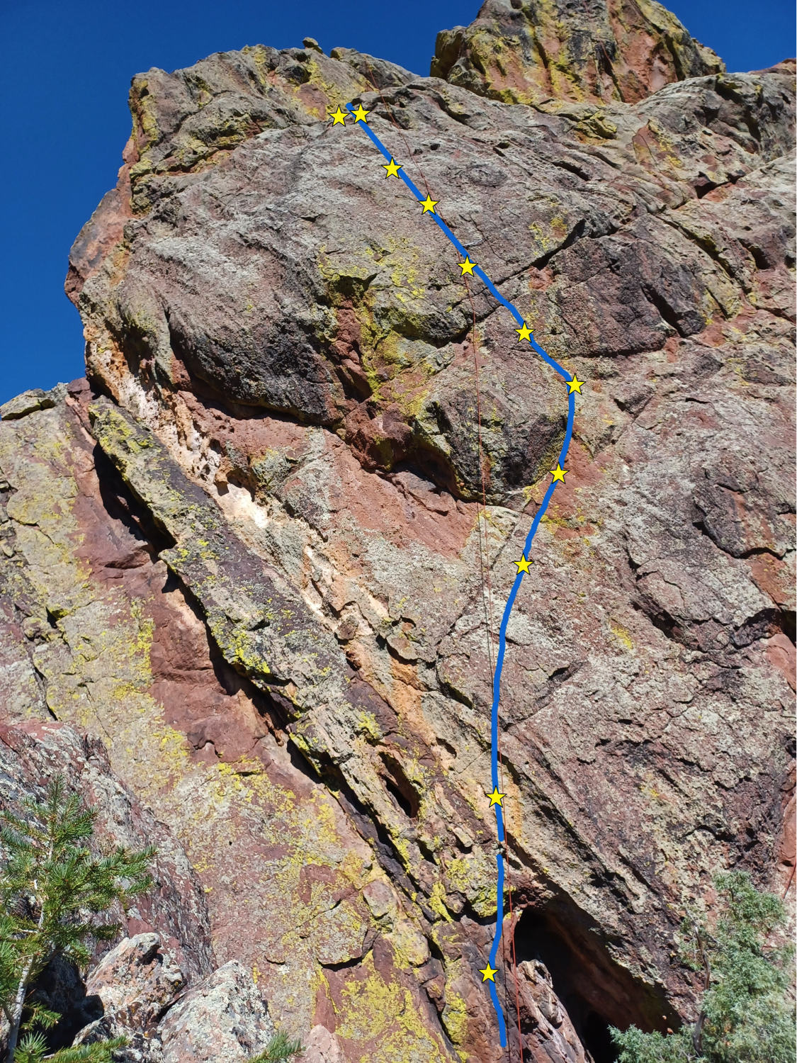
Proposed Route:
This route starts on a ledge at the bottom of the middle of the South face of the Finger Flatiron. Scramble up to the left side of the slot/cave and head towards the first bolt. The route heads up to a roof down low, passes it to the right, then trends left and up a steep face with pebbles and huecos. Follow a line of ten bolts to a two-bolt rappel anchor. It’s a fun line with lots of 5.10 and 5.11 climbing on mostly small face holds. The overall grade might be 5.11c or 5.11d.
Name Meaning:
The name, Sustainability Crisis, refers to the present state of affairs on planet earth, whereby us humans are not using resources wisely or sustainably… resulting in a full-blown crisis with nasty effects like global warming and climate change, soil degradation and crop failures, species extinctions, and many more.
Existing Route Information
The south face of the Finger has only two existing routes. Starting on the far right side of the south face, Mere Wall (5.8) is a trad line that follows a left-trending diagonal crack system. It heads up the south face for two pitches. The South Side of the Sky, a 5.12a sport climb, starts about 20 feet left of Mere Wall. It heads straight up for two pitches (5.11c, 5.12a) to the top of the south face.Existing Route Diagrams
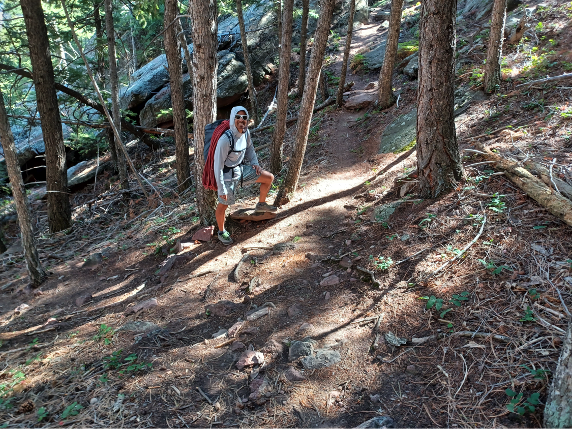
A description of the approach (include approximate distance from the designated trail system, existing “social” or undesignated trails leading to the climb and condition of the trail, and state whether there is a durable surface, such as rock.
There are two possible approaches, but the recommended approach is to start at NCAR and follow the trail to Mallory Cave. Just before arriving at Mallory Cave, take the climbers trail on the right, heading up past Red Devil and to the Box. As shown in the photo below, a small trail branches to the left from near the top of the main trail, and the west end of the Box. Follow this dirt trail south for about 30 yards past a roof/cave near the west side of the Finger Flatiron. Descend down, encountering some talus/scree, along the West face of the Finger another 50 yards or so to a prominent gully. Head east up the gully over large talus and rocks and you arrive at a large rock ramp system that trends down to the bottom of the south face of the Finger. This descent along the south face is steepish 3rdor 4thclass scrambling.

If different from the approach, a description of the descent, (include approximate distance from the designated trail system, existing “social” or undesignated trails, a description of the trail condition and whether there is a durable surface, such as rock. Include photographs of the descent.):
The descent will entail lowering or rappelling from the anchor at the top of the pitch. Climbers would then reverse the approach, returning down the Finger/Box/Red Devil trail to the Mallory Cave trail and back to NCAR.
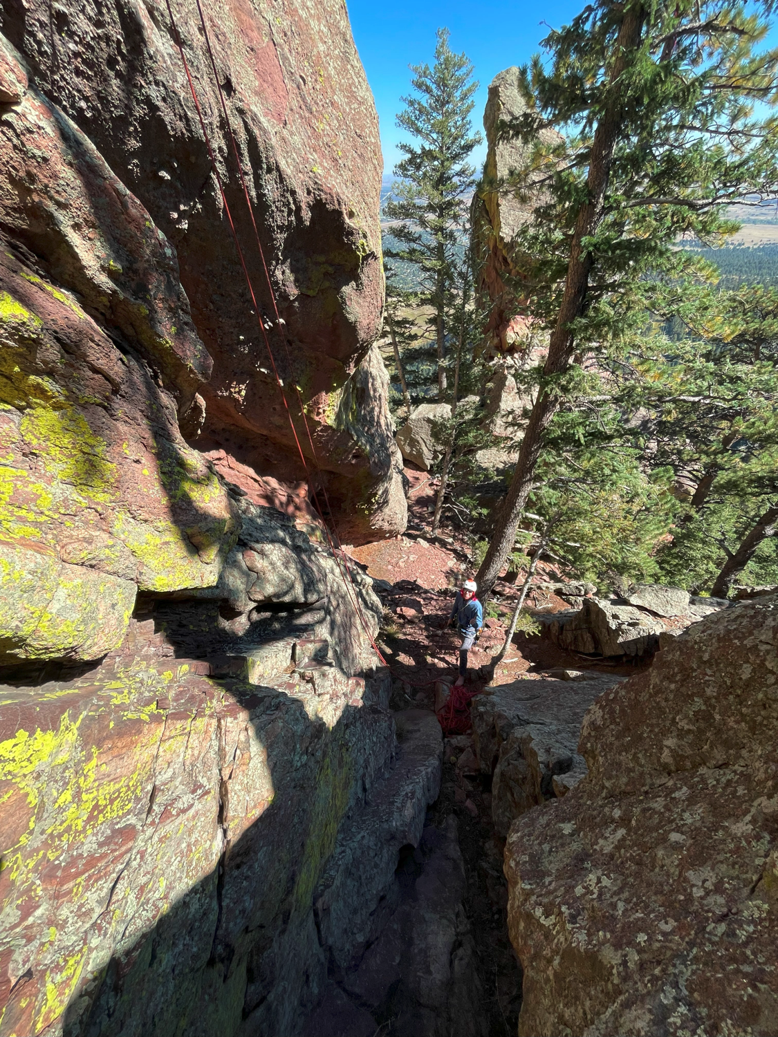
A description of the area at the base of the climb (include existing levels of soil compaction, existence of a durable surface such as rock, and existing soil erosion. Include photographs of the area at the base of the climb.):
The staging area at the base is rocky and sandy with a little dirt and some trees. This area doesn’t seem to get much climbing action, and it’s also fairly flat, so there is little visible erosion.
Has all reconnaissance work that can be reasonably done, short of placing any hardware, been done?
Base Area Photos
Has the route been top roped? Is there loose rock? Is it extremely overhanging?
Yes, the route has been top roped clean. There is little to no remaining loose rock. The rock is steep to vertical but not overhanging. As such, it was easy to inspect and climb in entirety.
Any additional notes:
The proposed route is fun, fairly sustained, and will add to the paucity of routes that exist there now (only two at this point), possibly making it a more sought out climbing destination than it is currently. The rock on this south face is very well-featured with many holds and possible lines. I’m also aware of another potential line to the right of this proposal that has been top roped and goes at a similar grade (5.11+). Furthermore, I recently learned that another line has been top roped to the left of this proposal and purportedly goes at 5.10. It’s likely that these other two routes will be proposed in future cycles.
News and Events
 OSMP/FCC Trail Day at The Slab: Trip ReportJuly 27, 2026 - 2:59 pm
 FCC/OSMP Trail Volunteer Day at the Slab July 25July 7, 2026 - 10:59 am
 2025 Flagstaff Trash Bash – September 4July 30, 2025 - 5:31 pm
 Trail Volunteer Day – Hillbilly Crag, October 26, 2024September 29, 2024 - 4:00 pm
 Golden Eagle Closures – New PeriodNovember 27, 2022 - 12:54 pm
- Trail Volunteer Day – First Flatiron, September 24August 24, 2022 - 10:54 am


Looks OK but it seems to skirt the obvious bulge between bolts 4 and 6, whereas the rope is hanging straight down the bulge on more interesting-looking terrain. But maybe there are no real holds there?
This looks good. Could it go more straight up between bolts 4 and 6, or is that bulge where the rope is hanging blank or contrived?
Looks like another great sunny addition to Dino Mtn. I am all for it
A nice-looking line. I vote yes!