
Route Name: Battle Cat
Application Status: Approved
Application Cycle: 2020
Rock Formation: The Hand
Number of lead bolts to be placed:
Number of anchor bolts to be placed:
Route Difficulty:TBD
Route Diagrams:
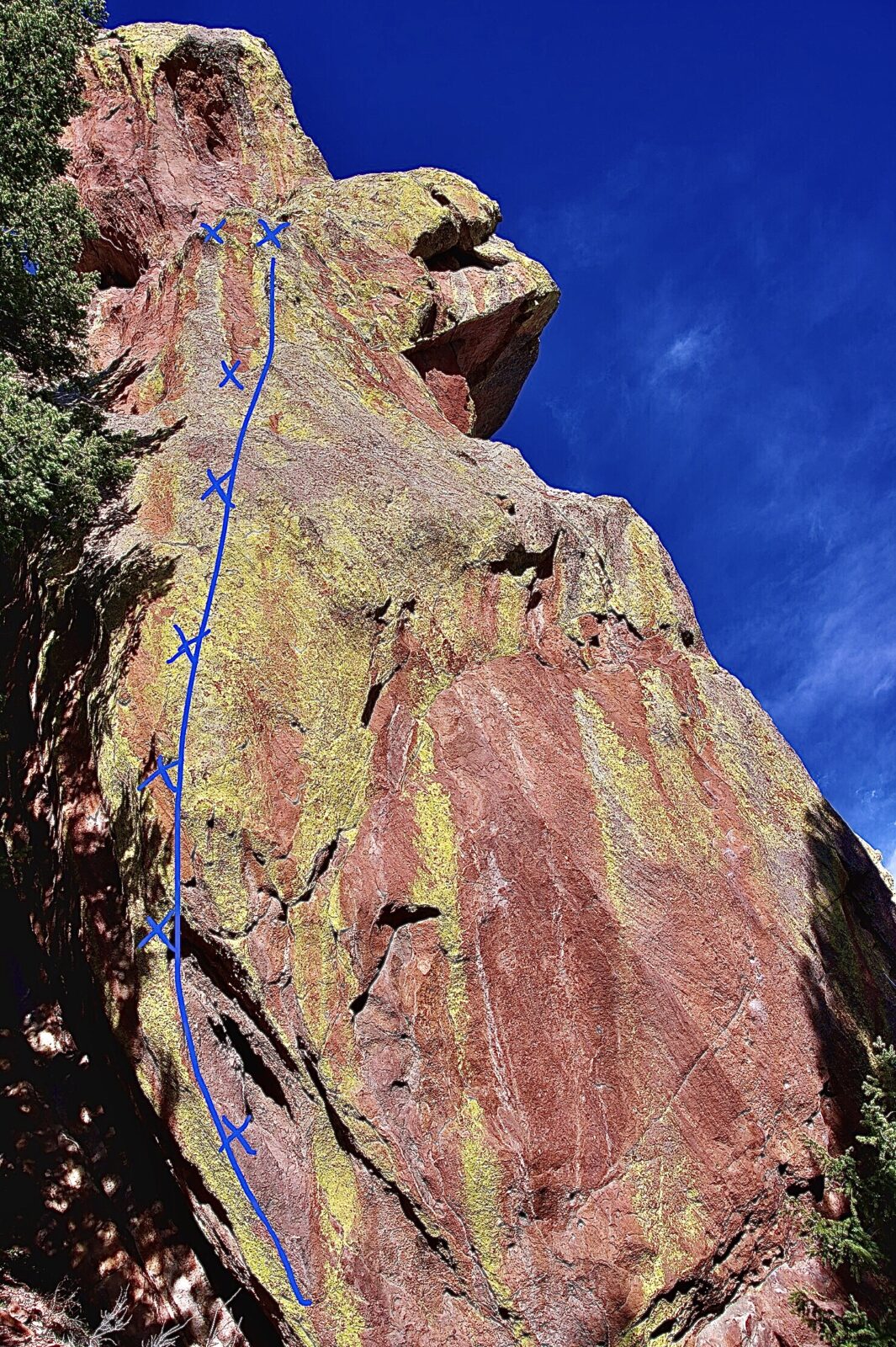
Proposed Route:
Battle Cat will occupy the left arete on the south face of the Hand. Power Bulge (12c sport) and Back In Slacks (11c sport) both sit to the right of the proposed route. Battle Cat will be 20+ feet to the left of Power Bulge.
Name Meaning:
Not provided
Existing Route Information
Existing routes on The Hand: Starting from the NW corner L to R The Handy Warm Up 5.10 New Saigon 5.11 Cardboard Cowboy 5.11 Father on Fire 5.10 The Perfect Kiss 5.11 Roc Atrocity 5.13 Power Bulge 5.12 Back in Slacks 5.11 East Face 5.4Existing Route Diagrams
A description of the approach (include approximate distance from the designated trail system, existing “social” or undesignated trails leading to the climb and condition of the trail, and state whether there is a durable surface, such as rock.
Approach is the same for the Hand formation, and well established. Park at NCAR Mesa and hike the Mallory Cave trail uphill for approximately 30-40 minutes. After passing the Der Zerkle formation, there is a faint climber's trail that skirts up the left side of The Hand's east face (slabby) into a rocky and wooded gully (if you find yourself at Mallory Cave you've gone a little bit too far). Continue up the gully, The Hand's south face should become aparant on the north side of the gully after several hundred feet. It is recognized by two sport lines that start on fifteen feet of enormous huecos. The west face routes can be found on the backside of the formation just uphill from the west face. Across the gully is Frankenstein's tower and Der Freischutz.
If different from the approach, a description of the descent, (include approximate distance from the designated trail system, existing “social” or undesignated trails, a description of the trail condition and whether there is a durable surface, such as rock. Include photographs of the descent.):
The descent is via lowering off the route.
A description of the area at the base of the climb (include existing levels of soil compaction, existence of a durable surface such as rock, and existing soil erosion. Include photographs of the area at the base of the climb.):
Soil is compact and base is slightly sloping, ideal for belaying. Clean and clear.
Has all reconnaissance work that can be reasonably done, short of placing any hardware, been done?
Base Area Photos
Has the route been top roped? Is there loose rock? Is it extremely overhanging?
The route has been top-roped/rope-soloed as much as possible given the severe nature of the climb. The middle section of the route is too steep to top-rope.
Any additional notes:
We're excited about this wild line! --- Additional (unmatched) --- Number of Bolts to be Placed: 9 bolts
News and Events
 Seal Rock Trail DayOctober 9, 2026 - 2:46 pm
 Trail Day at Seal Rock October 3September 15, 2026 - 8:37 am
 26th Annual Flagstaff Trash Bash ReportSeptember 6, 2026 - 2:46 pm
 Join FCC at the 26th Annual Trash Bash September 3August 1, 2026 - 11:47 am
 From Boulder OSMP “Seasonal area closures have been lifted”July 30, 2026 - 3:48 pm
 OSMP/FCC Trail Day at The Slab: Trip ReportJuly 27, 2026 - 2:59 pm


Meow that’s a nice-looking route. I say yes.
Technicolor glory! Yes.
I TR’d the line today in hellish wind/snow, and still had fun! All moves go, position/holds/moves are excellent and took minor cleaning. About 2x the length of Power Bulge. Potential for a second pitch to the summit, or a mega-pitch all the way up. Turned out better than I thought it would. Thanks for the support!
Rowr! Looking forward to another nice-looking route at The Hand. Yes please!
Looks like a good line on a crag that does not see much traffic. I support this route
yes
Looks great, yes
Battle Cat is also the name of a well known 8c in the Frankenjura
Meeooww!!! What a beaut’ of a climb, hopefully it’s as good as it looks! Yes to the battle cat!