Horsefly Hootenany
Route Name: Horsefly Hootenany
Rock Formation: Hillbilly Rock
Number of Bolts to be Placed: 9 bolts, 2 bolt anchor
Proposed Grade: 5.13a
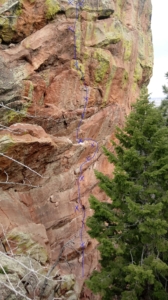
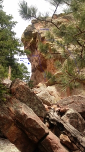
Route Description: Horsefly Hootenany climbs a severely overhanging panel on the climber’s left (north) side of the west face of Hillbilly Rock. It climbs 5.10/5.11 rock to a rightward traverse on small edges to a definitive crux, then moves back left on another crux traverse via small edges and slopers and heel hooks that ends in a difficult mantel. From there the route climbs steep, strenuous 5.11 on big, widely spaced bucket flakes to the top. The overall grade is estimated to be 5.13a.
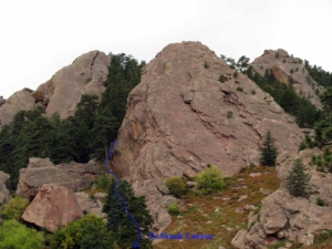
A description of existing routes on the same face of the rock formation, including the number of routes, route names, route grade, type [traditional or bolted], and approximate distance between routes (a photocopy or diagram of the existing route(s) is also required): The west face of Hillbilly Rock has two existing climbs, both 5.12. The leftmost one (West Face 5.12c) is located down and left 50 feet from the proposed line, and the second (rightmost) route (West Face Right; 512a) is located another 50 feet downhill near the southwest margin of the wall. Both are sport climbs, though West Face Right does have some moderate traditionally protected climbing to reach
A description of the approach (include approximate distance from the designated trail system, existing “social” or undesignated trails leading to the climb and condition of the trail, and state whether there is a durable surface, such as rock. Include photographs of the approach.): The approach is via NCAR. Take the Mallory Cave Trail to the Mesa Trail, head south to where the Mesa Trail traverses Skunk Canyon. Head west into Skunk Canyon on the climber’s approach trail, passing under The Guardian, then head due north up the gully between Hillbilly Rock and Ridge 1 to reach the west side of Hillbilly Rock on an existing climber’s trail. The trail is on durable, hard-packed dirt and talus.
If different from the approach, a description of the descent, (include approximate distance from the designated trail system, existing “social” or undesignated trails, a description of the trail condition and whether there is a durable surface, such as rock. Include photographs of the descent.): The descent is via lowering off the route back to the staging area.
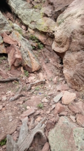
A description of the area at the base of the climb (include existing levels of soil compaction, existence of a durable surface such as rock, and existing soil erosion. Include photographs of the area at the base of the climb.): The staging area at the base of the climb is hardpacked dirt and rock, and is flat and comfortable for belaying.
Has all reconnaissance work that can be reasonably done, short of placing any hardware, been done? The route has been thoroughly inspected and cleaned on toprope.
Has the route been top roped? Is there loose rock? Is it extremely overhanging? The route is very overhanging but we were able to stay in on most sections with a directional piece. The route climbs solid rock minus a few thin flakes we removed and a few others we will need to remove when bolting, when we can stay into the wall better to clean.
Additional Notes: This will be a fun, severely overhanging addition to the wall that climbs at a higher grade than the existing sport routes. The movement is fun and athletic on good stone, with a definitive crux section in the middle 25 feet of the route bracketed by 5.11 below and above.


