Blush
Route Name: Blush
Rock Formation: The Mickey Mouse Wall
Number of bolts to be placed: 13-lead bolts + 2 bolt anchor
Route Difficulty: 5.12+/13-
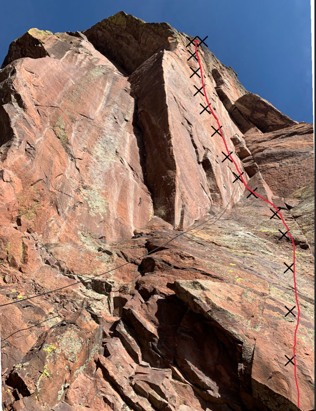
Route Description:
This is an entirely independent pitch on the beautiful and slightly overhanging face just to the right of Stigmata. The route will be accessed via the first 2 pitches of Red Arete/Red Dihedral. The new pitch is long and sustained, with both technical and pumpy climbing. The grade is expected to be 12+ or 13-.
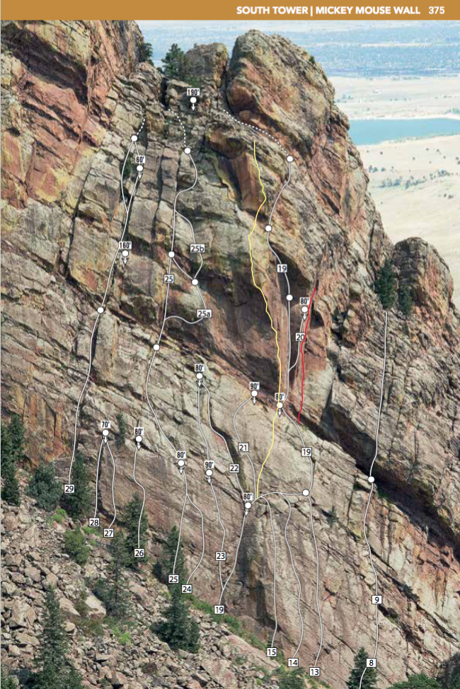
A description of existing routes on the same face of the rock formation, including the number of routes, route names, route grade, type, and approximate distance between routes (a photocopy or diagram of the existing route(s) is also required):
There are numerous routes on Mickey Mouse Wall that are well documented in Steve Lavin’s “Eldorado Canyon, A Climber’s Guide”. The established routes include a mix of trad and sport.
Routes in the immediate vicinity include:
13: Asahi (5.10c, trad/bolted)
14: Perilous Journey (5.11c, trad)
15: Krystal Klyr (5.11a, trad)
19: Red Dihedral (5.12d trad)
20: Stigmata (5.13b, trad/bolted)
21: Boxcar Willie (5.11a sport)
22: The Green Dihedral (5.7+, trad)
23: Plane Geometry (5.12b, mostly bolted)
24: Leap of Faith (5.12a, trad)
25: Simian’s Way (5.10 trad)
26: Mighty Mouse (5.12a bolted)
64: Three Mouseketeers (5.11c bolted)
Yellow Line: Red Arete
Red Line: Redface (proposed route)
A description of the approach (include approximate distance from the designated trail system, existing “social” or undesignated trails leading to the climb and condition of the trail, and state whether there is a durable surface, such as rock.
The approach to Mickey Mouse Wall is well documented on Mountain Project. Here is an excerpt:
To reach Mickey Mouse Wall, take the road to Eldo and turn left on County Road 67 (paved) right before the town. Go about 300 yards to a locked gate. Park here.
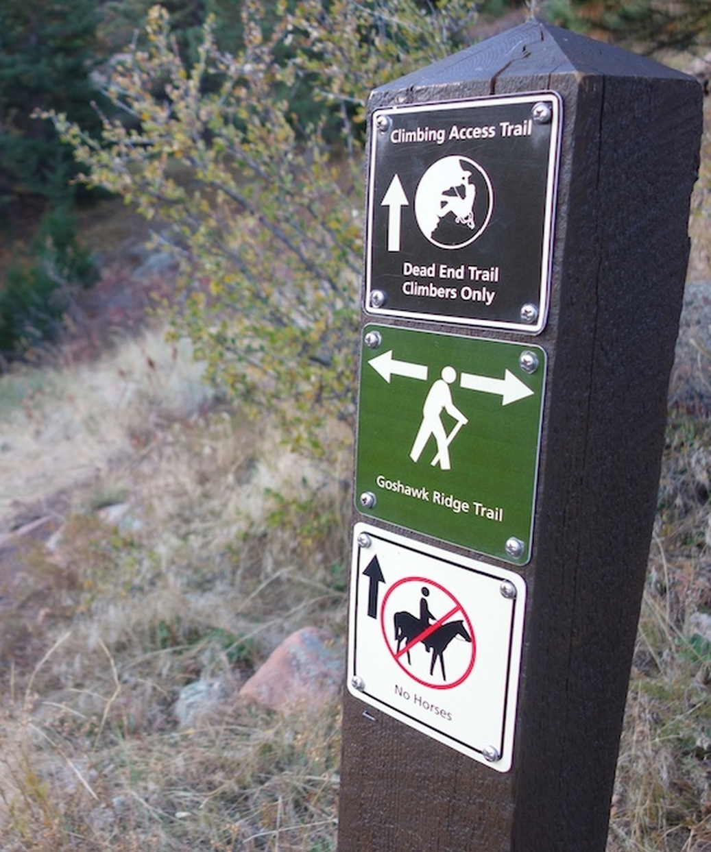
Hike up the maintained gravel road, avoiding a left after about 0.5 mile, and continue through a rock cut. Continue hiking up the road aka “Fowler Trail” avoiding a few single track trails heading off to the right. Continue hiking up the road avoiding roads that go off to the right up to the Conda Quarry. At an intersection with a road and a gate on the right continue straight onto a double track for about 100 feet and then take a right onto a single track.
Continue on the single track avoiding a left single track aka “Goshawk Ridge Trail” all the way to the train tracks.
When you arrive at the tracks, turn left and walk along the east side of the tracks towards the tunnel (tunnel 6). About 20 feet before the tunnel, take a faint trail up the dirt berm on the left.
The wall is immediately on the other side of the tunnel. Please DO NOT go through the tunnel. You will climb approximately 200 feet contouring uphill to skirt around the east side of the tunnel, generally paralleling the direction of the tracks. Eventually you will crest the ridge and start descending, continuing to contour around the ridge until you arrive back at the tracks. Promptly cross the tracks and continue towards the wall on the southwest side of the tracks. There is a very poor trail right under the wall, and big talus (preferable) a little to the left. Hike up to your route.
If different from the approach, a description of the descent, (include approximate distance from the designated trail system, existing “social” or undesignated trails, a description of the trail condition and whether there is a durable surface, such as rock. Include photographs of the descent.):
The descent will be via lowering off the route.
Staging area:
A description of the area at the base of the climb (include existing levels of soil compaction, existence of a durable surface such as rock, and existing soil erosion. Include photographs of the area at the base of the climb.):
The staging area at the base is the same as for Red Arete and Red Dihedral since it shares the same first two pitches. It is rock, with no pre-existing vegetation.
Has all reconnaissance work that can be reasonably done, short of placing any hardware, been done?
Yes. The route has been thoroughly inspected, and several options have been explored to find the best line.
Has the route been top roped? Is there loose rock? Is it extremely overhanging?
The route has been top-roped/rope-soloed.
Any additional notes:
Should be another good addition to the wall.


This route looks like a great addition, I vote yes.
Looks like a rad panel to round out the Mickey’s Hardperson Clubhouse, a yes from me.
A very worthy new line. Yes please!